
Lake District
 |
 |
|
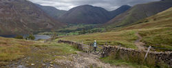
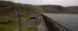
10.09.25 Whin Rigg and Illgill Head The last day of a 5 days in the Lakes. The weatherman was suggesting that if we went out early, we could avoid the heavy rain. We got up around 6ish and were on the road shortly after. The plan was to tick off Whin Rigg and Illgill Head, and it seemed like walking the length of Wast Water was going to make for a decent circuit. The ascent from the lake up the side of Greathall Gill proved to be exhausting this morning. |
09.09.25 Burnbank Fell, Starling Dodd and between A pretty long hike today, but 5 new Wainwright fells to tick off. We saved this hike for today as it was due to be the best weather on this trip. A mixture of sunshine and light cloud, mild wind and zero rain. That's a pretty perfect forecast. I really enjoyed the start of this walk and the gradual traverse along the side of Burnbank Fell. I must say though, it's summit was one of the most under whelming I have visited. |
|
 |
 |
 |
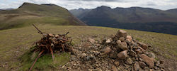
08.09.25 Middle Fell, Seatallan and Buckbarrow This was an enjoyable little circuit. Firstly up Middle Fell. A fell that keep teasing me with false summits but once at the true summit, some great 360 views. Then a big drop in elevation and up the very steep side of Seatallan, with views across to Sellafield and the coastline. Lastly, down to Buckbarrow and some confusion of what three possible cairns was considered the summit. We made sure to stop at them all. |
07.09.25 Hard Knott The the drive to the hike is sketchier than the hike itself. We had it there though with no issues for a very short 2km return trip. Further bog dodging and a summit with an amazing view to the north. |
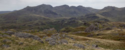
07.09.25 Grey Friar Rain expected by midday so we set out nice and early for a direct route to the top of Grey Friar. This morning was windy but this made it more exciting, plus we didn't see anyone else, which is always a win. Oh, and we dodged some very angry sounding cows. It was nice to walk along the side of Seathwaite Tarn reservoir and the faint track leading up Tarn Brow and Goat Crag was just about visible. |
 |
 |
 |
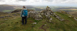
06.09.25 Grike, Crag Fell and Lank Rigg Day one of a 5-day break in the Lakes. I did very little research on this route but found it to be pretty tame, initially. Whilst up on Crag Fell I managed to injure my ankle whilst diving for Catherine's top, which was about to be blown off the summit. With considerable discomfort, I managed to make it to the bottom of Crag Fell and decided to push on with great care and see how I got on. By the time we reached the top of Lank Rigg, I had little pain at all. Phew! Not much to write about on this route. It was gentle without many features. I'd call it a nice warm-up hike. |
27.07.25 Seat Sandal Arriving at the car park for the start of the walk, I shut down the car to a load bang and a jolt forward. My handbrake module had failed! With not much else I could do, secured the car and set off for a hike. The plan was to stay another night but now those plans had to change. Today's hike was for myself to bag one Wainwright, but Catherine would get 3. As often the case, we started with a pretty steep ascent, gaining height quickly with great views. |
26.07.25 Fellbarrow and Low Fell This hike has been on my list for a long time but kept getting cut. I had read that the views would be superb, and we were not disappointed. Starting with a very gentle start, we made our way around and up Fellbarrow, stopping only briefly as we continued on to Low Fell and the amazing views down to Crummock Water. The rest of the hike followed a not always obvious track back round to Loweswater. |
 |
 |
 |
16.03.25 Great Dodd, Watson's Dodd and Clough Head. Last day in the Lakes and we are returning to fininsh the Dodds. I'm actually pleased that we broke them up into two walks and also pleased that they start from opposite sides. Ascending the Dodd's from the east side was alot more gradual and less dramatic, but seeing as this was day 5 of hiking, it was very much welcomed. |
15.05.25 Back of Blencathra. If today goes as planned, we finish the northern fells region. Another dry day, feeling pleased that we waited for the right time of year to hit these fells. Even the deepest bog had a crust on top, which also meant we could move much quicker. |
14.05.25 Bakestall and Great Calva. The track/road into the hills from Peter House Farm provided a very gentle start as it slowly ascended towards our targets for today. That relaxing amble suddenly ended as we turned right for a very steep climb up onto Bakestall. Fortunately the wind which had been plaguing us for the last 2 days was now blocked off by the Skiddaw range. After descending back down the same very steep track, there was no rest. It was straight up the other side on an even steeper track up towards Little Calva. |
 |
 |
 |
13.05.25 White Side, Raise, Hart Side & Stybarrow Dodd. Originally planned to be a longer hike, cut short by the wind. Next to none down in the valleys, but up in the hills it was mentally tiring. I was having to cover my ears as it felt like the wind was trying to blow out my brain and it was hard to hear much of anything. Other walkers we came across seemed to share the same disappointment. It was a lovely clear day with great views but it meant that we didn't want to linger. |
2.05.25 Carrock Fell and High Pike. 5 days in the Lakes! The weather forecast for the week was looking great, but would it stay that way? After frustrating delays on the A66, we got to Mosedale at 2pm. The start of this hike was pretty steep, but what made it worse was the bone dry ground beneath our feet. It was also extremely windy today. Question - Why is there no trees around here? |
17.03.25 Raven Crag, Armboth Fell and High Rigg. Another multi-hike day. Today we reached three new Wainwrights across some pretty rugged terrain. The first hike, we set off on without bags, which meant no water and no snacks. By the time we got the car, we were ravenous. |
 |
 |
 |
16.03.25 Binsey, Ling Fell, Sale Fell and Graystones. After a day traveling up to the Lakes, feeling very unwell and losing an exhaust pipe, it was a surprise to get any hiking done. How we did 4 new Wainwrights today, I don't know. This was to be a day of several short hikes and multiple car parks. |
21.04.24 Hallin Fell and Steel Knotts The Lake District must have changed since we were last here a year ago. You can now plot 3 whole days of hiking and not have the weather impact your plans!!! Our last hike was an early sunday morning and a chance to bag a hill that we cut short from on a previous visit to martindale. A nice quiet morning with very few people around when we started. |
20.04.24 Tarn Crag and Steel Fell I was slightly concerned with this hike being a bit on the boggy side. Looking at 3D mapping of the route, I would see that it had the potential to be very rugged and not overly obvious trails. apart from helm crag nearby, my knowledge of this are was pretty limited, especially around Tarn Crag and Calf Crag. |
 |
 |
 |
19.04.24 Arnison Crag Having just got back down from place fell, we crossed to the over side of the road, setting our targets on arnison crag (another wainwright). The weather was looking as though it may change due to the distant rain clouds drawing nearer. It was a quick summit bag, so we went for it. |
19.04.24 Place Fell Straight out of the car, after the usual 4 hour drive to the lakes, and heading for the summit of Place Fell. This is day 1 of 3 intended days hiking in the lakes. I say intended, because often, the weather disagrees. |
18.06.23 Great Mell Fell Heading home along the A66, we stopped for a quick bag. A muggy morning but only a short hike. The views were gorgeous, making it harder to leave. |
 |
 |
 |
17.06.23 Beyond Skiddaw This trip the the Lake District has had it's challeneges. Firstly, the 9hr drive which should have been 4 hours and then today, we start our walk with a GPS and no power. Fortunately, I had a map and a good memory of how i drew up this route. The weather forecast threatened rain butI'm pleased we ignored taht as it never really came. |
21.05.23 Knott Rigg and Ard Crags Another early morning start. We enjoyed the drive from Keswick through Newlands. We started our walk from the decent sized car park at Newlands Hause. A very liner walk and pretty quick too..A very linier walk and pretty quick too. A bit of heavy breathing to get to Knott Rigg and then some easy walking to Ard Crags. |
20.05.23 Firefighter Mountain Challenge Last year we completed this chaLlenge and raised £2000 for east anglia air ambulance. This year, some more money raised and tougher conditions. just as we did last year, the challenge was to climb and descend scafell pike in full fire kit (minus boots) and carrying breathing apparatus. we hadn't seen anyone do this with b.a. sets on before. |
 |
 |
 |
19.05.23 Walla Crag I struggle to stay still for very long when I can see mountains around me. Having travelled up today, climbed Little Mell Fell and walked down to Keswick and back, I somehow still felt restless. Tent all set up at Castlerigg Farm, I decided to have an amble up to Walla Crag. I didn't really know the track leading to it, I just saw it and figured it out from there. It turned out to be a very pretty walk. |
19.05.23 Little Mell Fell The shortest Wainwright route that we have done. Only 1.2km! I felt like we were cheating from this start point but it seems to be the common point of attack. |
08.05.23 Selside Pike, Branstree and more. This was one of those hikes where we tried to tick off as many Wainwright's as we could. It's also one of those areas where it's best to venture onto during a dry spell. That being said, there are areas here consisting of year-round bog. It's fun dodging bog, it's not fun losing the entire leg in it. |
 |
 |
 |
15.09.22 Longside Edge and Dodd I've looked across at Dodd for a while now and wanted to climb it. The fact that it's covered in trees has added to my interest. On it's own it seemed like a short walk, so i added some Wainwright summits that Catherine needed to bag which I had already visited. It made for a really great route. The woodland was gorgeous and so was the ridge walk too. |
13.09.22 Hartsop Dodd, Caudale Moor + Gray Crag My legs were still feeling a little tired from yesterday but even if they were well rested, they still would have screamed at me as we ascended Hartsop Dodd. Our route took us from Sykeside Campsite, across the road and directly up the west face of the fell. This could be one of the steepest climbs I have done! |
12.09.22 Middle Dodd and Red Screes Whenever looking on a map at Middle Dodd and Red Screes, it always felt they were out of the way and not easy to string into a decent sized walk. What makes that harder is when there are viable tracks leading to these peaks that aren't visible on a 1:25 O/S map. Fortunately a bit of internet research showed me that there is sometimes more out there not drawn on a map. This helped me find a way up Middle Dodd and a route directly from my campsite. |
 |
 |
 |
21.05.22 Firefighter Mountain Challenge Here is something you don't see every day in the hills. One of the guys on my fire crew came up with the idea of this challenge and we ran with it. We chose East Anglian Air Ambulance Charity to raise money for and managed (at time of writing) £1300 |
24.04.22 Skiddaw Not quite what the weatherman had predicated. A guy on the summit of Skiddaw was recording wind speed of over 55mph. I felt at times like I was going to get blown off the mountain. Funnily, on occasions if you moved 10-10ft to the side you couldn't feel the wind blasting over the mountain side. This was a great walk near Keswick with the opportunity to tick off some more Wainwright's. |
23.04.22 Grange Fell For a year now, we have owned a rooftop tent. It's really opened up our opportunities to doing more than day trips as sleeping in a roof tent is a lot more convenient and definitely cheaper than hotels or Airbnb. Today was the start of one of our weekend trips to the Lakes with the main task of ticking off more Wainwright's. |
 |
 |
 |
18.04.22 Bowfell and Esk Pike I'd been either side of Esk Pike many times over the years but never on it. Today my intentions were to fix that and for Catherine to finally put her feet on Bowfell. A 10 mile route finishing with a visit to Rossett Pike made for a full day of mountain adventure. |
17.04.22 Pike of Blisco A lot of the iconic views of the lake district come from Langdale. Blea Tarn provides many spots for taking great photos if you afford the time. Not only is the tarn stunning but it's surrounded by dramatic crags and buttresses. |
07.09.21 Wansfell and Baystones OK, so this is a quick one. Last time we visited Wansfell, it was cooking and we didn't get over to tick off Baystones (Wainwright summit), so today, scorching again, we went back to get it bagged. Very few photos taken today. I'm not really sure why. Maybe the heat was getting to me. |
06.09.21 Melbreak and Hen Comb Last time we tried to do this hike, we had to turn back about 3/4 of the way up due to awful wind. Today was quite the contrast. It was pretty much perfect weather. Sunshine with enough high cloud cover to keep it reasonably cool but with great visibility.
|
22.07.21 Whinlatter Another one of those brutally hot days, but who lets that stop them from hiking? With sun cream slapped over every inch of exposed skin, we headed up onto Whinlatter. The initial ascent route within the Aiken Plantation wasn't obvious and was initially questioned. It was going up though, sometimes that's enough to know. As with many lakeland walks for us lately, it's all been about bagging Wainwright's and today we managed to visit several. A bit of a detour over to Barf but so worth it for the views. |
21.07.21 Walla Crag and Bleaberry Fell You can see some epic views from above Keswick but which one is the best? Latrigg? Dodd? Catbells? or could it be today's view from Walla Crag? The ascent of Walla Crag is pretty quick so we added in Bleaberry Fell too. Both offer up some amazing views.
|
18-19.06.21 Martindale Round and wild camp Recently we bought a huge map of the lakeland fells to stick up in the house and use drawing pins to highlight the wainwright's we have done and the ones we still have to visit. This map looms over us in the dining room and makes easy planning for future hikes. My problem is that I like to squeeze in as many as I can into each hike. |
24.04.21 Eagle Crag and Beyond It's great to visit some of those smaller attractive summits but I have this habit of turning what could be a small short pleasant hike into something a bit more exhausting. It's become a common trend since I've been looking into reaching all the wainwright's.
|
23.04.21 High Street and Kidsty Pike Kidsty Pike has been on my hitlist for some time. It was nice to revisit this quiet, remote area after several years. It was also nice to be taking the route up Riggindale Crag again. I loved this ascent last time because of its views and light scrambles. It turned out to be a pretty hot day for april but we were not complaining. |
10.09.20 Great Gable from Honister Only my second time ever summitting great gable. The last time was 12 years ago! This time i wanted to hike it from a different side. One thing i instantly noticed from today's route was that it is a whole lot less strenuous than hiking from the bottom of Wasdale. The added height gain from starting at Honistor slate mine makes a huge difference.
|
08.09.20 Wetherlam via Steel Edge One of those unsuccessful photo days where I didn't want to risk my camera taking a soaking but still got soaked anyway. I'd been wanting to do this hike for some time, since seeing the ascent of steel edge online. It looked like a good sCramble on a quiet route in an area i hadn't yet visited. The most memorable aspect of this hike though is it was the first full day of married life to new wife, Catherine. What a way to spend it!! |
06.09.20 Wansfell Pike Here are some photos taken on my phone from a very impromptu romp up to Wansfell Pike from Ambleside. When we arrived in Ambleside the weather wasn't looking favorable for a hike. Fortunately, and this is weird to say but the 1 hour driving around Ambleside looking for somewhere to park worked out well because there was a sudden shift in the conditions and sudden clear summits. |
 |
 |
 |
07.12.19 Causey Pike This was one of those walks that turns out to be more dramatic than expected. Starting off in Braithwaite we set off on a walk into Newlands which hugged low to the road for some time but once we started to head upward, things got really impressive. Causey Pike is a peak I've not really understood in the past. I always saw it as a small addition to a range of other simple peaks. Turns out this walk was a cracker and with small scrambles to make it even more exciting. I drew this route up to include several Wainwright's and it's definitely a route I will do again. |
06.12.19 Castle Crag With weeks and weeks of rain I was expecting a break at some point and my fingers were crossed it would be dry for our annual Christmas Lakes trip. As you will see from the photos, we lucked out to some extend but we didn't let it stop us. We could have easily stayed in a nice warm pub but we waterproofed up and didn't regret it. In fact, it was to wet that I didn't even want to take my camera with me. All of the photos were taken with my phone. |
24.03.19 Pillar A quick direct attack of Pillar from Wasdale. Last time I did the High Level Route and seeing as the visibility would be poor, it made sense to make this a short trip out. We reached the summit for breakfast at 09:30am and then shot back down the way we came up. No surprise to see the summit clearing as we looked back. Typical!
|
28.10.18 Glaramara and Great End Here's one we have been hoping to do for a while now. The ascent route we took was very steep but intersting at the same time. Finally got onto Great End, a summit I've passed by on several occasions whilst climbing to Scafell Pike. Another spot I've always bypassed was Seathwaite Fell so it was great to tick that one off too today. |
27.10.18 Sheffield Pike Really surprised by this one. The ascent was fantastic with views across Ullswater which got better as we climbed. The view fro Heron Pike is one of the best in the lakes! Descending from Sheffield Pike to the disused mine works was a bit on the boggy side but it wasn't long before we were back onto dry ground and a pleasant path down to Glenridding Beck. |
19.05.18 Old Man of Coniston Oh my god what a hot day it was! It was Harry's Royal Wedding Day so maybe that explained why it was so quiet. Or maybe people are more sensible during a mini heat wave. The plan was to summit Old Man of Coniston and then traverse some more peaks. We decided against that idea by the time we reached Levers Hawse and chose to descend from the Prison Band. |
 |
||
18.05.18 Langdale Pikes Today was about getting Catherine doing a classic Lakeland scramble but also to tick off a bunch of surrounding Wainwright's too. It may have only been 11km but adding the scramble to some pretty rugged terrain meant we were really feeling it towards the end of the day. Luckily we had great weather!
|
25.02.18 Fairfield Horseshoe Here's a pretty big walk and a Lakeland classic round. I'd been unimpressed with the photos i'd seen of it one but i can confirm that mine don't do it justice either. It's a great route covering a lot of ground with some interesting features. The view down from Rydal Head is really dramatic... you'll see. |
24.02.18 Loughrigg Fell I've finally started looking into consciously ticking off some wainwright's. I've done most of the high ones so now I'm looking into the smaller fells. Loughrigg Fell was close to where we were staying and I'd heard great things about it's summit. Time to start trying out these smaller fells and see if they can compare visually to the biggies.
|
16.12.17 Whiteside and Beyond Yesterday was a pretty short walk with not much in the way of excitement. I wanted today's walk to be a bit more of an advenutre. The route I had planned would be more dramatic and higher too, meaning more snow. This route starts quite tough, it's a steep climb up to the summit of Whiteside but with that, you gain height quickly. from then onwards we were in the snow, and it was pretty deep in places too, especially descending Hopegill Head where a few of us ended up on our backsides.
|
15.12.17 High Seat Visiting the Lakes in December could be called a regular occurrence now and it usually follows the same format, 2 days of walking, beer, curry and mince pies. Day 1 is the day we arrive so we usually do a short walk. Today's walk was planned for a small series of hills we had not yet visited. Unfortunately due to the snow and terrain we cut out Bleaberry Fell and went straight for High Seat. |
11.11.17 A Kentmere Round + High Street One of the popular Lake District Horseshoe Walks is the Kentmere Round. This is one I had been itching to do for some time. I was also keen to be heading back to High Street too. (I figured why not add it to the horseshoe? It's close enough) It turned out to be a pretty gorgeous day with only a short section of bog hopping in the afternoon. This route ticks off quite a few Wainwright's too if that is your goal.
|
 |
||
17.06.17 Helvellyn and Striding Edge Scrambling through fog to find the summit of Blencathra only the day before, it was a real shocker to wake up to the most perfect conditions for our Helvellyn ascent. I attempted to do the same fell last November, only to be faced with horrendous weather conditions. The snow and poor visibility wasn’t the main problem, but it was the thought of either slipping on the ice or being blown off the ridge by the gale-force winds that made me a bit nervous. So it was with great disappointment -nevertheless a wise decision - that our little group came to a mutual decision to abandon the hike.
|
20.03.16 Scafell Pike from Seathwaite Another day in the Lakes and more superb weather! How lucky we were feeling and you never know what's around the corner whilst in this part of the country. Today's walk we have done several times because it's so good! Lot's of great scenery, a vast array of views and summiting the top of England. I was a bit apprehensive though this morning...
|
19.03.16 High Spy After meeting friends in Penrith we drove off to the small village of Grange in Borrowdale (Just beyond Derwent Water). I was excited about today's walk as it was somewhere I hadn't visited before. I'd hadn't even known about this route until recently so I was surprised to find it whilst researching online. It's always good to have a walk that has something more than just a summit. This one had mine works and a summit with great views in every direction.
|
06.12.15 Catbells after Storm Desmond Reading the weather reports on the days leading up to our trip to the lakes didn't faze me at all. I think weather reports are often wrong and usually seem exaggerated. There was no denying that the tail of a storm would hit scotland and northern England but i still planned for walkable weather assuming it was all going to be fine.
|
31.05.15 Gowbarrow Fell Day Two and a few of the girls had a great idea of taking a boat trip along Ullswater. The rest of us visited the nearby Aira Force Waterfalls and summited Gowbarrow Fell. The weather report today read as pretty awful with heavy rain all day. Well it's a good thing we don't pay too much attention to the weatherman because we had rain for about 10 minutes and the rest of the walk was what you would call T-Shirt weather... mind you it was very blowy on the top of Gowbarrow. I've also got to say that the traverse around the south side of Gowbarrow was stunning. |
30.05.15 Skiddaw A couples weekend in the Lakes was suggested a while back and since then I was worried about what I could plan that everyone would enjoy. Well I think I managed it! All sorts of ideas were juggled around including walks of different levels, boat rides and shopping. Day One would involve climbing up Skiddaw for those who needed a high level fix and shopping in Keswick for those who didn't fancy the slog. I was surprised to see that everyone was up for Skiddaw but very pleased we would all be together.
|
13.12.14 Fleetwith Pike and Haystacks It was a cold start to our afternoon walk. We set off from Gatesgarth Farm and ascended Fleetwith Pike. From the side this route looks like a razor sharp ridge but on it you realise it's a pretty straight forward walk with occasional mild scrambles. The view back as we climbed is one of the best you can get in the Lakes and it was mostly unobstructed from the clouds. The wind was biting though so we pushed on and only took short breaks to admire the scenery.
|
28.07.14 Pillar (Wild Camp) As soon as we reached the summit of Pillar we set out to find the flattest, greenest ground to pitch our tents on. Within 20 minutes we were all set up with sleeping bags out and mats inflated. I sat in the stone summit shelter and brewed up a coffee. Paul offered me a generous dash of spiced rum and I ate one of those tuna meals you get in an aluminium tin. I don't think you need great food on a mountain as everything seems to taste better after you have put the effort in climbing up.
|
28.07.14 Pillar (High Level Route) Here is a route I have been wanting to do for years but each time I visited Pillar in the past the conditions were not ideal for this indirect excursion. We also planned to wild camp on the summit and hopefully have a clear night. On the days leading up to our trip I thought very carefully about what I should take up with me. I wanted my pack as light as possible by only taking the absolute essentials. When I met up with Paul and Geordie in the car park at Wasdale I was shocked at how heavy their packs were. Nearly twice the weight of mine Later I wasn't surprised to see how much food they were carrying. |
 |
||
12.01.14 Catbells and Maiden Moor A quick up and down Catbells was extended slightly today by heading up Maiden Moor. The bitter wind was harsh at times but we were not ready to go home just yet. Fortunately the cloud remained high so we had great views. It was Noah's second trip up Catbells in 6 years. He lead the way and encouraged us to extend our journey. |
29.06.13 Old Man of Coniston Looking at the weather the decision was easy. Rain in Snowdonia, Sunny Spells in the Lakes. Choosing the route was easy too. This was to be my first visit to Coniston, something I had been hoping to do for a while. Getting to Coniston was amusing and a lesson was learnt. 'Don't rely completely on satnav!' Arriving at a ferry crossing on Windermere had us more than surprised. Easily corrected though by heading for Ambleside and circling the lake. |
18.11.12 A Coledale Round +Grassmoor With twelve of us together today covering different walking abilities and a few with limited visits to the Lakes, I wanted to choose a route that wasn't technical, could be extended and pack a punch with the views. The Coledale Round does all of those, or as I call it, 'A Coledale Round' because you can mould it any way you like. I was also keen to make it slightly different compared to when I did it last, back in 2009 and add a new summit visit. Another good thing about this route is there is a couple of escape routes for those feeling tired. |
17.11.12 Honister Via Ferrata The day finally arrived! When I first heard about the Via Ferrata route at Honister Slate Mine, it had just been closed down due to some re-routing work around wild plantlife. Now its back with a new Xtreme route aswell. Seeing as half of us are firefighters, it seemed only right that we should commit ourselves to the more exposed course. Not to say we dont tremble at sharp falls like anybody else. We arrived at mid day with a delayed start. Someone in an earlier group was taking a considerably longer time to complete the course. This didnt help lessen the fear already expressed in Shaun's face. lol!
|
22.05.12 Blencathra via Sharp Edge After a night of no sleep in Priest's Hole Cave, was I ready for Blencathra? I don't think I was and I certainly wasn't ready for the sun. Note to self - Hot,Sunny day, WEAR HAT! Parked up on the A66 near Scales farm, we shot up Blencathra pretty swiftly. Plenty of people about today including a bus load of school kids. Most likely a geography class interested in the Glacial Tarn. I must say that by the time I was halfway up Sharp Edge, I was feeling pretty tired. That blazing sun certainly didn't help. Also, my watch strap broke on Sharp Edge. Not the best place for a dive but I managed to save my watch despite seeing the pin fall over the tarn side of the edge. |
21.05.12 A Night in Priest's Hole Cave I cant be certain where I learnt about priest's hole cave but i think it may have been a feature in a copy of trail magazine a few years ago. Last year I did a walk around Deepdale and noticed the cave way off in the distance over the other side of Dove Dale as I walked along Hartsop Above How. Since that day I had intended 2012 to be the year that I spent a night in the cave. A couple of months ago we agreed a random date where we were all free. Incredibly that random date wasn't during the month long rain assault in Apr/May we will remember for years to come.ad picked probably one of the most perfect nights you could get! |
10.12.11 Scafell Pike Our little expedition was increased by 3 last night after our walk above Newlands (see here) with the arrival of Andrew, Ben and Geordie to our Lakeland retreat. It was good to see Ben again as I hadn't seen him since the Everest Trek last year. Today's route was a bit of a classic! A day of unsettled weather is once of the better times to visit Scafell Pike.. Thus eliminating the crowds. Although we got a little more snow than expected. Our ascent route was up Styhead Gill and along the Corridor Rout. I wanted to mix things up a little from Seathwaite Farm as I usually go up Grains Gill. The journey towards Styhead Tarn was a real ankle twister. Boulder strewn and icy with plenty of boggy patches, it required all of our concentration. Reaching the snowscape views across to Great End, Broad Crag and Lingmell Fell, it was very difficult to see the ascent line through all the white stuff. The gang were all new to the Corridor Route and a little unsure of where I was leading them. Once we found the track below Great End, the route ahead became clearer. There was a few moments of uncertainty due to the track being buried and at one point we found ourselves briefly in a precarious position.
|
09.12.11 Robinson, Hindscarth, Dale Head It looked like a light dusting of snow on the fells from down in Newlands this morning. The moment we left the cars, the skies unleashed a heavy bombardment of hail stones and later that day it seemed the weather had plenty more ammunition up it's sleeve. Our first summit, Robinson, was tackled by ascending High Snap Bank. A grassy ridge leading to a couple of fun, simple scrambles to the summit. After a brief rest with hot coffee at the top we followed Littledale Edge to Hindscarth. This turned out to be quite a slog due to very deep snow. We all managed to lose our feet once or twice and occasionally an entire leg. During our traverse over to Hindscarth's summit the weather gave us more than our fair share of strong gales and snow, which resulted in another very brief summit visit. our nice summit was dale head and Due to there being plenty of thick snow and a not so obvious path our descent didn't look partiCUlarly inviting so we decided on an alternate route. We weaved our way down towards dalehead tarn through the deep snow and joined the path leading back to little town just before the rain. today was tough but it was also the first time in snow this year and that's almost always something to smile about.
|
10.09.11 Helm Crag Returning from our trip to Arran we took an overnight pit stop in Ambleside. The next morning we set off for Grasmere. After parking at the village school, we packed our waterproofs and made our way to Easedale. The ascent of Helm Crag was pretty quick at 405m and rather muggy. It certainly looked like it was going to rain at some point. Up on top with very strong gusts I managed to balance on the Lion for just enough time to get myself snapped. I tried to climb up the Howitzer aswell but it was far too slippery today. We then continued along the ridge by traversing the boggy ground over Gibson Knott, Moment Crag, Pike of Carrs, Calf Crag and Brownrigg Moss. Up on the ridge was very bleak! Horizontal rain, gale force winds and the very boggy ground made for a very challenging day. The descent into Far Easedale wasn't much easier either, as the becks were bursting from all the recent rain to the point where the paths were looking more like becks themselves. We squelched back to Grasmere, windswept and tired. It may have been nasty weather but as usual it was still a great day in the Lakes. |
03.08.11 Bow Fell and Crinkle Crags After a rough nights sleep with a rude awakening on the campsite at 4am by some very inconsiderate campers we set off for Bow Fell. It was cloudy when we started and very muggy. As we made our way up the grassy slopes of The Band a fellow walker told us that it was 30 degrees in London. It felt like that here, I thought. We decided to veer right and take the Climbers Traverse to the Great Slab. We then clambered up the rock fall to the summit of Bow Fell. Once at the top the clouds cleared which was great for Raz as he would then see the great views but not so good for me because i forgot to pack the sun block and it was roasting. We traversed across Crinkle Crags and made our way back down to Oxendale. By this time my legs were weary but Raz looked as if he was strolling in a park. Another great day out. I Really hope to go walking with Raz again someday. |
02.08.11 Pavey Ark and Jack's Rake Today was the start of a special trip to the Lakes. Our friend from Nepal and Mountain Guide Raz had accepted our invite to come along. This was Raz's first trip to the UK and it made sense to bring him here. We set up camp in Great Langdale and followed the path alongside Stickle Gyhll to Stickle Tarn. After some time messing around by the water we climbed up Jack's Rake to the top of Pavey Ark. The scramble itself was really good fun and we had some time taking photos from the half way point where it briefly levels off. Raz looked out from the summit of Pavey Ark and commented on how beautiful the scenery was. Fortunately the cloud had just cleared giving us great views out to the Coniston Fells and Windermere. The evening was spent in the Old Dungeon Ghyll Pub. I recommend the beef pie! |
14.05.11 Haystacks (Wild Camp) After a brief visit to Keswick and a final stock up on supplies we headed off to Buttermere with the intention to wild camp somewhere around Haystacks. During the drive down Honister Pass the clouds were looking dark and swollen. The weather man had said there was a small chance of rain but knowing his regular errors and the ever changing conditions in the Lakes we really didn't know what we were going to get. Setting off from Gatesgarth we made the steep fun climb up Fleetwith Pike. As we topped out very dark clouds were about to surround us. We made our way over to Haystacks where the conditions improved and we welcomed the occasional wind breaks as we weaved through the crags approaching Haystacks. After about an hour of searching for the ideal location we settled for a better panorama rather than shelter. It was reasonably flat and springy though and a rare dry area. By 9pm it was freezing outside the tent so we settled down for the night. Morning arrived after what seemed like an eternity of looking at the roof of the tent and listening to the rain. We packed up and made our way back down via Scarth Gap. It was only a short trip away but still a worthwhile adventure. Next time though i'll ensure more wind protection. |
25.02.11 A Deepdale Horseshoe We woke up at the YHA to the sound of rain. Our friend Andy who we met in Nepal last year had decided to come along and we were all ready to go at just after 9am. We ascended St Sunday Crag with hoods up and heads down. Visibility was awful and the our ears were ringing from the strong winds. We took our lunch stop in a low area on Deepdale Hause to shelter from the wind and continued on to the scramble up Cofa Pike. Just a few minutes later we were up on Fairfield and looping around to Hart Crag. By this time the weather was perking up, blue skies were breaking through to the east and the weather became mild and warm with great views out to the High Street Range and across to Ullswater. Me and Andy B reminisced about our trip to the Himalayas and discussed the latest happenings in the fire service. Scott persisted with his descent method of sliding on his backside down the wet grassy slopes and we had some fun hopping across the boggy sections around Hoggill Brow and Bleaberry Knott.
|
24.02.11 Helvellyn from Patterdale When we reached Patterdale in the morning it was warm and sunny. It managed to remain that way as we made our way up Grisedale Brow. When we arrived at the Hole-in-the-Wall, the cloud over Nethermost Pike was creeping towards Helvellyn. Typical timing! By the time we got on Striding Edge visibility was very poor with strong gusts of wind making the traverse that bit hairier. As we made the final scramble up to the summit of Helvellyn it became apparent that the crampons and ice axe on my pack were nothing more than unnecessary weight as we didn't need to negotiate any snow or ice. It was no surprise once on top that we weren't rewarded with any views so we made our way in the clouds over to Nethermost Pike, High Crag, Dollywaggon Pike and down to Grisedale Tarn. A long decent through Patterdale Common and Grisedale saw us back to Patterdale. After freshening up at the YHA we spent the evening relaxing in the White Lion Inn. |
21.08.10 Scafell Pike and Scafell The problem with living so far from my favourite walking destinations is that you really don’t know what the weather will throw at you until you get there.
|
20.12.09 - Catbells The original plan today was to take on a snow dusted Scafell Pike but when we arrived at the edge of Seathwaite in a snow shower, we were a little concerned about continuing down to Seathwaite farm and getting snowed in due to the weather reports on the radio. In the end we turned back and decided to leave the cars close to Keswick so we could do the quick climb up onto Catbells. We left the cars in Portinscale and followed the very icey road down to the foot of Catbells. At the start of the climb Derwent Water was completely hidden in a snow shower but it didn't take long to clear. The wind was at times pretty fierce, the rock was very icey and it continued to snow heavily as we climbed. Once at the top there was a sudden turnaround in the weather conditions. The sky became clear and we were warmed by the sun as we sat eating our lunch. We had the summit to ourselves and that's pretty rare on such a popular peak. |
19.12.09 - The Coledale Round Today we all met up in Penrith at 8.30am. We had 2 new walking friends with us, both called Andy and both great guys. We started from Braithwaite at the car park near the edge of the woodland and made our way up onto Grisedale Pike via Sleet How. The weather was clear and bright but very cold on the exposed peaks. After a short break we continued on to Hopegill Head, down Sandy Hill and up onto Crag Hill which was then buried on cloud. We descended and took the path between Outerside and Causey Pike back to Braithwaite. We must have seen a maximum of 6 other people, one of which was a lady waiting on the steep edge of Sail as her partner descended to hunt for her air bourne down jacket. I wouldn't have fancied doing down there. That evening we went for beer in Cockermouth and took a curry back to our favourite cottage. A great end to a great day! |
31.10.09 - Helvellyn and Striding Edge The weather report for today kept changing throughout the week. The last time we looked at it it said dry with sunny spells. When we arrived in Glenridding and looked at the route ahead I didn't see a great deal of blue sky. We followed the path beside Mires Beck up onto Birkhouse Moor and continued to the Hole in the Wall. Helvellyn's summit was buried in cloud and Striding Edge was about to be also. Up on Striding Edge it was very slippery and windy. Alan and Geordie led the way with me attempting to take photos in the rain behind them. (not very good photos) Once at the top of Helvellyn with only approximately 1 hour of daylight remaining we chose to descend via Swirrel Edge and then follow Red Tarn Beck back down to Glenridding for dinner at The Travellers Rest. (and a few beers) |
04.07.09 - Scafell Pike Early next morning in Wasdale the cloud seemed to be more broken and patches of blue sky were visible. We set off along Lingmell Beck and made our way steeply up the side of Piers Gill. This has a great feature to the walk which had some fun scrambles and sheer drops. ( I split the crotch on my trousers here which became a conversation piece later on) After Piers Gill we took a right and followed the cairns straight up to the summit of Scafell Pike. The summit was covered by cloud so no views and it was cold, but its always great to be on Scafell Pike! Our descent took us along Lingmell Gill back down into Wasdale. |
03.07.09 - Pillar and beyond Starting late in the day we left from Wasdale Head where we had pitched our tent. As we took the path through Mosedale up to Black Sail Pass we assessed the cloud line which was covering all the peaks and seemed to be getting lower. We summited the cloud covered Pillar by taking the direct route and enjoyed a rewarding apple. We then descended slightly and made our way up to Scoat Fell and across Red Pike. At Dore Head we decided not to tackle Yewbarrow as it was getting late and we wanted to get back to Wasdale Head Inn for supper so we chose to follow the path beside Over Beck, around Yewbarrow and onto the road back to Wasdale Head. We didn't make it in time for dinner but the beer went down well. Visiblity was close to zero so didn't get to take many photos. Atleast it didn't rain! |
02.05.09 Above Buttermere Starting from Gatesgarth we took the steep ascent up onto Fleetwith Pike. We then followed the path up to Haystacks admiring Blackbeck Tarn and Innominate Tarn along the way. We stopped for lunch on one of the jutting out crags on Haystacks and enjoyed the view down to Buttermere. We continued on down Haystacks, across Scarth Gap and up onto High Crag and then High Stile. We then made our way to the top of Red Pike before descending down to Buttermere via Bleaberry Tarn. The day started out cloudy but by mid afternoon it was sunny and warm. |
06.02.09 Skiddaw At 6am this morning I set off with Lee, Geordie and Paul from Lincoln. We started from Peter House Farm, followed the track up to Barkbeth Hill and joined the Allerdale Ramble. We briefly used crampons when we ascended a very frozen Ullock Pike and stopped for coffee on Longside Edge. We then split off from the Allerdale Ramble and with Crampons and axes in place we followed a very steep track up to the Summit of Skiddaw. At the summit I was looking forward to a well deserved drink from my hydration bladder. Unfortunately due to a school boy error the fluid in the drinking straw had frozen solid. We then descended Broad End, made a cock up my descending around Cockup instead of the easier route over and then joined the path back to Geordie's car at the farm. |
08.12.08 High Street Today's walk started at about 10.00am from the Mardale Head car park. We ascended the long ridge of crags at Riddingdale up onto the High Street plateau and through the deep snow across to the summit. We then made our way south across Mardale Ill Bell. The original plan was to go over Harter Fell but the wind started to pick up and we were running out of time so we descended Nan Bield Pass. Here the snow was very deep. In some places it was up well above our knees. This route presented quite a challenge and was very enjoyable even though we all lost our footing several times. We passed by the frozen tarn and continued down along side Small Water Beck and back to the car park. That evening we had dinner in Cockermouth and spent the night at the excellent Croft House Barn. |
23.08.08 Great Gable Starting at Wasdale Head, we crossed through Burnthwaite farm and followed the track along the beck around to Sty Head and then straight up to the summit of Great Gable. We then descended the western side. We lost track of the track briefly that leads to the bottom. Rod retraced his way back onto the path and i continued down the scree beside the Gill which rejoined Rod near the bottom. The weather was warm and cloudy. We snacked on granny smith apples, cashews and cake bars. |
 |
||
22.08.08 Ennerdale It was 4pm when me and Rod decided to take a quick trip into Ennerdale. When our wives asked how long we would be we said, approx 2 hours. We got back at 10.30pm. We started at the car park near Bowness Knott, walked along the length of Ennerdale Water and continued down and across the bridge near the bottom of Pillar. We then returned along the other side of the lake and around via Anglers Crag. As we passed the head of the lake we got attacked by midges and then as we passed Mireside we got dive bombed by bats. The weather was mild and warm. |
22.08.08 Derwent Water We took a walk from the Keswick Launch along the left side of the lake, stopped briefly at Friars Crag and then continued a bit further round where we had lunch. Later we went back to Keswick Launch and joined the boat ride round Derwent Water. The weather was warm and sunny. |
21.08.08 Catbells An easy walk made difficult. Rod carried Lucas (2 months) and I carried Noah (4 yrs) when i could. We started from the car park near Hawes End and made our way up the two humps of Catbells. Noah took some persuading but when it came to the short scarmbles he took off like a crag rat. We came down by the Allerdale Ramble to the road below and were picked up in the car. I fell on my behind when i slipped near the bottom which Noah found highly ammusing even though he was on my shoulder. It was a cloudy day but mild and warm. |
21.07.08 Blencathra and Sharp Edge Wild Camp Today Me, Geordie and Lee had decided to wild camp on Blencathra. We parked up just off the A66 near Scales and took the footpath behind Scales Farm. We continued along the valley between Scales Fell and White Horse Bent and then up the wet rocks of Scales Beck. We arrived at Scales Tarn at about 7pm and set up camp. At around 8pm we followed the path to the right up onto Sharp Edge and then scrambled up to the Blencathra Plateau. We then descended an unmarked path approaching the other side of Scales Tarn completing a horseshoe back to camp and enjoying a late HotPack dinner. The night was very windy and a very tired Geordie encouraged us at 4am to pack up and return to the car. |
23.05.08 Crinkle Crags and Bow Fell We started today's walk with 7 pint hangovers. We were surprised we hadn't scared off our new friend Sandra, who met us at the campsite car park. We took the path to Stool End farm, crossed the bridge over Oxendale Beck and started our ascent up Browney Gill. We then crossed over the Crinkles and the Bad Step up to Bow Fell. We said goodbye to Sandra and descended down the Great Slab, across the narrow Climbers Traverse and down The Band back to Langdale. The morning started cloudy then became warm and sunny. Bananas and Jaffa Cakes seemed to be the most popular today. |
22.05.08 Pavey Ark via Jack's Rake This was the first walk of our two day stay in Langdale. The 6 of us set off from Great Langdale campsite, headed up Stickle Ghyll to Stickle Tarn and then took the scramble route up Jack's Rake to the summit. The weather was sunny and calm. We power snacked on a variety of sweets, Jaffa cakes and Bananas. In the evening we went to the Old Dungeon Ghyll for Beef Lasagne and Chips/Fish and chips. Sandra who we had seen earlier at Pavey Ark joined us for the evening and quickly leant that firefighters can be quite vulgar. |
17.04.08 Helvellyn from Glenridding Today's walk started with a 5 hour drive from Home via Sleaford to pick up Geordie. We collected Crampons and Ice Axes from SummiTrek in Ambleside and pitched a tent at Gillside campsite in Glenridding. The sky was blue and the weather was calm throughout the day apart from a little snow during our descent late afternoon. We power snacked on Dairy Milk and dinner was a nice steak and ale pie washed down with extra cold Guinness at the Inn on the lake in Glenridding. |
15.03.08 Pillar from Buttermere The weather report said rain all day. We didn't get a drop. Only problem as you can see was a big old cloud that covered the top half of Pillar. 7 of us from the fire station i work at were on this walk. We started from Gatesgarth farm in Buttermere, over Scarth Gap Pass beside Haystacks, down into Ennerdale and past the Black Sail Yha, up Black Sail Pass, a brief view from Looking Stead and then up to the summit of Pillar. The plan was to take the High level route but visibility made it too difficult and it was very slippery so turned back onto the direct route. Power Snacked on some nasty Spicey peanuts and later had steak and ale pie in one of the pubs in Cockermouth. |
01.09.07 Scafell Pike Today's weather was mostly cloudy and cold. The summit was buried in a rain cloud and we got soaked. Visibility was near zero from half way. We started at Seathwaite Farm and took the path to Stockley Bridge, followed Grains Gill but ignoring Sprinkling Tarn, turned left and then right up to Esk Hause and then right again up to Great End, past Broad crag to descend briefly then back up to the summit. Oh did i say we got soaked?! Power snacked on bananas and a mars bar. Had steak and ale pie in a pub in Cockermouth. |


